![]()
![]()
![]()
![]()
![]()
![]()


This is a selection of walks fairly close to Callander most of which are within 30 minutes of Lenymede Bed and Breakfast. For walks in other areas close to Lenymede bed and breakfast go to Central Trossachs Walks Page or the Harder Walks Page.
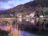 To both overnight visitors and day trippers, the Callander Meadows are a popular spot for a gentle stroll by the river or the opportunity to sit and enjoy the panoramic view which stretches from the meadows and the tree lined hills beyond to Ben Ledi in the west. Here too you can feed the ducks and swans or if you have children with let them enjoy the small play area.
The best place to start is at the bridge that takes the Glasgow road over the River Teith. From the centre of the bridge you have the most beautiful view over the meadows with Ben Ledi as the backdrop. Look carefully into the river's waters and you may salmon or trout swimming by. Taking the path sign posted 'To the Putting Green', you first pass, on the left, the grassy knoll known as Tom na Kessaig or Hill of Saint Kessog supposedly from which this missionary from Iona preached and was later the site of an early church.
Follow the river's edge until the path ends and then either return or continue close by the river until you reach tarmaced path leading to the right back to the meadows car park or to the left to join the cycleway. This latter gives you the opportunity to cross the river by the old railway bridge and if you continue for about two hundred yards you can pass through a gate on the left and cross the fields to the 'Little Leny' graveyard at the 'Meeting of the Waters' where the two rivers Eas Gobhain and Garbh Uisge (better known as the Leny) meet. Here you will find the burial place of the Buchanans which has the oldest local identifiable historic date of 1214. The adjacent mound was the site of the original Chapel of Leny.
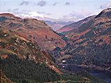
The Oban Railway Line, a victim of Dr. Beeching's axe in 1965, is now a cycle way and provides excellent walking up through the Leny Pass, along the shores of Loch Lubnaig, and on to Strathyre. With the option to travel one way by bus or postbus, this route offers a combination of farmland, woodlands and lochside landscapes of captivating beauty. The route also offers alternative views of the Leny Falls, since it is passes on the opposite side of the river from the normal access.
The total distance to Strathyre is about 9 miles, but you may tailor your walk according to your ambitions. Possible options include descending to the Leny Falls and returning by one of several paths through the woods that follow close by the river. Watch out for deer, foxes, stoats and woodpeckers as well as many woodland birds. Of particular interest are the large ant hills, two to three feet high, that may be seen hereabouts. The turn-off point for the falls is at the second of two brick and concrete blocks now set in the path coming from the Callander end at which you descend to a path on the right.
My favourite section is the following one mile stretch leading up to the car parking area for the Ben Ledi walk which is just situated off the Stank Road. If you are looking for a short walk (2 - 3 miles), then you can drive to this point and walk to Leny Falls and back. This one mile stretch no longer follows the old course of the railway, which crossed on a now demolished bridge to the other side of the river. Instead you follow a path that gently switchbacks through mixed woods, primarily oak and birch, along the river with frequent views of the sparkling waters much frequented by dippers. Continue on to Loch Lubnaig and further to Strathyre or even Balqhuidder where you may visit Rob Roy's Grave.
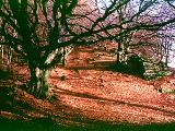 Overlooking Callander is the steep rocky ridge known as the Callander Craigs, the lower slopes of which are thickly wooded with several excellent paths that provide tranquil woodland walks. These walks may be as short as fifteen minutes or several peaceful hours. If you feel fit, take your choice of two paths that take you up to the top of the Craigs in about an hour. This is highly recommended, especially for the views of Callander spread out below, Ben Ledi in all its glory, Loch Venachar, and also of the Forth Valley with Stirling Castle and the Wallace Monument visible to the sharp eye. Access to the Lower and Upper Woodland walks can be made from several points within minutes of the high street. Any of these Craigs or woodland walks may be combined with a visit to the Bracklinn falls.
Start at the western end of town. The footpath is accessed at the side of the Callander sports Centre on Tulipan Crescent. Take the left hand path and climb steeply through mixed woods containing some magnificent beech trees. Take care since beech mast provides a soft loose surface and much of the old wooden steps are rotten. The Forestry Enterprise have recently (end July 97) displayed a path closed sign, though its condition is relatively unchanged since last year and requires the care that one would normally apply to a hill walk as opposed to a pedestrian path.
After crossing a small bridge and passing several points where the trees open out to provide views over Callander, you cross a final bridge to the summit where a cairn and stone commemorate Queen Victoria. You may return from the summit to the bridge from which a steep descent can be made to the Upper Woodland Walk. Currently there is a closed path sign, however two small children and myself found no problem. On reaching the Forestry track, cross it heading slightly to the right and follow a path down to a bridge where you can go right to return to the starting point or straight on to descend to the Main Street.
Alternatively, from the summit continue to follow the path down the other side, a fairly gentle descent to the farm road (2 kms). Again you have a choice; turn right and walk to the Bracklinn Falls car park and 100 metres on turn right onto the Upper Woodland Walk. Follow this to the Forestry track and cross diagonally right; you have now joined the previous option - continue as above. Alternatively, turn left and follow the road for 1 km. and turn right and take the track down to the bridge over Keltie Water. Cross the bridge ( side excursion here on the right to the 'Scout's Pool' ) and follow the track through forest up and over continuing to open farmland. On reaching a fenced field on the right follow the fence line to a gate, enter the field and descent the slope to the bottom corner of the field. Enter the woods on the right through the 'gates' and take the path to the right (approximately west) to Bracklinn Falls. Continue on to the Bracklinn Falls car park and rejoin the alternative route described above.
 A visit to the Leny Falls can be combined with several peaceful woodland walks that start at the Leny Falls car park, one of these leads to the summit of Meall Garbh with extensive views over Callander and on to Stirling Castle and the Wallace Monument. The lower sections of these walks pass through oak woods where once charcoal was made. The whole area abounds with bird life and at the right times you may be lucky enough to see deer.
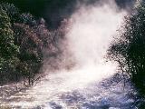
The Falls are a short walk from the same car park, on the other side of the road. and when there is a good flow of water are a magnificent sight. The river here is very popular with canoeists who relish the excitement of passing over these falls. An alternative way to visit the Falls is via the disused Oban railway line footpath. either from Callander, about 2 miles or from Stank Road, about 1 mile.
Strictly this walk should perhaps be in the 'Harder Walks' section, but as a combination of the three previous walks it fits in here. This is not a difficult walk, but is longer than the previous ones and crosses open country which is very tussocky so be sure to wear boots with good ankle support and carry a map and compass. The best map for this and other hill walks in the area is the 1:25,000 Harvey's Trossachs East.
Ascend Callander Craig to the cairn and find a point to cross the fence on the left without damaging it. Follow the high ground NW on a bearing of 305° magnetic with the Balameanoch Woods on the left. Walker's map shows a spot height of 347m. The walk takes you up Creag Bheithe, down the ridge to Meall Garbh then up to the summit and this is clearly visible from here. Below are the headwaters of the Leny Burn, which to the left enters a steep sided gorge. You cross the burn and continue heading in the direction of Cnoc Dubh.
From the spot height, 1½ kms on a bearing of 319° magnetic brings you to a wide col near Cnoc Dubh; traverse left in a generally westerly direction whilst gaining height. Your target is Creag Bheithe which you ascend to a forestry fence line at grid reference NN601101. Turn left and follow the fence line in a south west direction until you reach a corner where the fence turns left. Cross the fence and ascend Meall Garbh keeping the woods on your left.
Follow the waymarked path steeply down to the southwest until you reach a col and a path crossing left to right. Turn right onto grassland and descend diagonally left into woodlands, mostly silver birch. Find your way to a wall bounding an open field at the bottom. Cross the wall and follow it left until a gate takes you onto the A84 road, which you cross and take the Stank Road 25 m to the left. Cross over the river and turn left to join the Callander - Strathyre cycle and walkway. Three miles sees you back to Callander. Total distance approximately 12 kms.
An easy and pleasant walk to view these lovely falls produced where Keltie Water crosses a hard band of sandstone and conglomerate rock, the bedding planes of which have been tilted to a nearly vertical angle; the falls are at their best after some rainfall. The name derives from the Gaelic 'breac' meaning trout and 'linn' meaning pool. The return trip from the nearby car park takes less than an hour. Look for deer, hares, foxes and birds of prey especially in the early in the morning.
A short easy walk to a couple of interesting local features and offering nice views towards Callander and of the Leny Pass. You can either walk or drive to the point where the cycleway crosses the road at Kilmahog, car parking available. From here turn left up the road and where the forestry track with a barrier goes up right pass through the gate just to the left and climb the hill diagonally left gradually rising above the road. Continue up aiming for the summit of Bochastle Hill from which there are excellent views up the Leny Pass and of Ben Ledi. Continue along the line of the hill towards the west until you reach the large glacial erratic which is perched apparently precariously on the side of the hill. This is Samson's Putting Stone.
The next hill to the left is Dunmore the site of a Caledonian or Pictish hill fort built as a defence against the Romans. As a point of interest there are two other hill fort sites in the area including one near Bracklinn Falls. Descend from Samson's Stone and with care cross the wall and climb up the east side of the hill progressing more to the northern end. Eventually you can see the clear remanents of ditch and embankments. When you reach the summit you will see that on the north side it is protected by three of these defensive features and in the centre is what has been said to be a well, though it may in fact just be a rain filled hole. This is a wonderful spot bringing you close history and with excellent views. Continue down the western edge taking care not to go to near the southern slopes that fall away steeply. At the bottom head for the gate leading to the road leading back to the car park or if you walked from Callander take the turning to Invertrossachs on the right and back to Callander that way. on this route you may also take a side trip to the shores of Loch Venachar.
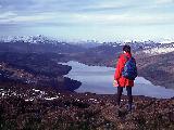
For really excellent views over Callander, Loch Venachar,The Trossachs and the Forth Valley, walk up Ben Gullipen, a relatively gentle walk to a mast topped summit at 414 metres. Park at a large lay-by on the left of the A81 just about 6 km. from Callander. Cross the road and climb the gated track.
Also spelt Sheann and the Ben above is known as Beinn an t-Sithean, so you takes your choice. A lovely walk through forest until reaching open ground from which are excellent views of Loch Lubnaig, and then open hill walking into and along Glen Buckie.
About 8 miles, 4 hours, steep at first but an enjoyable walk. Start at OS reference NN558173 where there is a signpost for the Ben Shian Walk (blue waymark) and the shorter Bailefuil forest walk (green waymark). Follow path up through forest to a forestry track and turn right. Just as the track swings left then right look for a path on the left - this may be obscured by bushes. Climb this path into mature forest and continue until reaching open ground ignoring the green waymarked path leading off right. Cross the stream at the forest edge to reach a clear view down Loch Lubnaig.
Continue ascending diagonally up to ridge and follow footpath through gate. Now descend diagonally right into Glen Buckie eventually passing above Immeroin Farm. Cross drystone wall via style and join farm track leading to road to Balquhidder. Though the remainder of the walk is by road the scenery is pleasant with lots of wildlife for the keen eyed. Take the right hand turning for Stronslaney Farm and follow this single track road to return to Strathyre, initially following the River Balvag and then through forest.
Starting from the same point, OS reference NN558173, as the previous walk continue to the point where a footpath leads right indicated by a green waymark. Take this path and continue along a forestry track with fine views over the valley. On reaching a major forestry track going left follow the sharp hairpin bend right. This track continues to the point at which you crossed it near the beginning of the walk. Watch out for the path ascending right, waymarked, and continue on 100 metres and descend left to the starting point. An easy, enjoyable walk, approximately 5 kms.
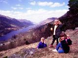 Starting at Balquhidder Church, the site of Rob Roy's grave, this 3 km. walk offers stunning views down the Glen with Loch Voil stretching away into the distance. Follow the Kirkton Glen path steeply up through forest and turn right just after the water supply building on the right. Ass you approach a small hill on the right look for a signposted path leading up it to the top of a rocky outcrop overlooking the church. This is a pleasant spot for a picnic with plenty of grassy areas for a quiet siesta. Descend by the alternative woodland path back to the church.
 A nice easy walk through a lovely glen though with a steep start if commencing from Ardchullarie More on the west shore of Loch Lubnaig at grid reference NN584137. This is the best end start from if very whet or icy since the gradient is gentle on the descent to Loch Earn at the other end of the walk. Beware of the river ford approximately 0.6 km. south of Glen Ample Farm at grid reference NN597198. After heavy rainfall or a thaw in winter this crossing can be extremely treacherous and it is advisable to take the higher forestry track to the west.
This was one of the first hill walks I did in this area and is a nice introduction to the higher hills near Callander. The walk starts at the point where the previous walk finishes at grid reference 602224 on the South Lochearnside Road. Harvey's East Trossachs map is best not because of the extra detail but because the route awkwardly straddles OS sheets 51 and 57 (the same is true for Ben Vorlich direct and Glen Ample walks. The distance is 12 kms (7.5 miles).
The walk is relatively gentle, but offers fine views of Ben Vorlich, though the appearance of its path to the summit is more daunting than the reality. Across Loch Earn the Ben Lawers group and Tarmachan Ridge are a fine sight and to the east can be seen the Braes of Balqhuidder.
Take the track due south from the Falls of Edinample which provide a wonderful when the water is running well. The track runs besides the Burn of Ample and on your way there are many peaceful spots beside tranquil pools. After 1½ kms. turn off the track just before a bridge over the burn and take the footpath going right and shortly ascend the hillside where the burn has cut into it. Take care here, since the path is breaking up. Continue to a small wooden bridge and cross it.
Follow the fence on the left until you cross a small burn (may be dry in summer) and follow the red waymark left up a small embankment until you reach a track leading into Glen Ample farm. Turn right and follow this upwards. This is the most difficult section navigation wise since the path leading to the Ben Our track seems relatively little used. Be sure you take the higher track that leads off in a generally easterly direction (approximately 109° magnetic). Climb steadily SE for nearly a kilometre then more easterly for 0.7 kilometres at which point the track abruptly disappears. Climb steadily NNE (30° magnetic) until you you reach 726m, descend to the col and climb finally to the summit of Ben Our (OS sheet 57) or Ben Or on the Harvey map.
For details of a other walks accessible from Lenymede Bed and Breakfast look at the following pages;
For further walking information go to the Hill Safety, the Walk List, the Walking Links, the Dynamic Database (IE4 only) or the Maps Pages.
For further activities information go to the Main Activities, Activity Holiday Page, Cycling, Fishing, or Golfing Pages.